
User priorities first: speed, clarity, and confidence
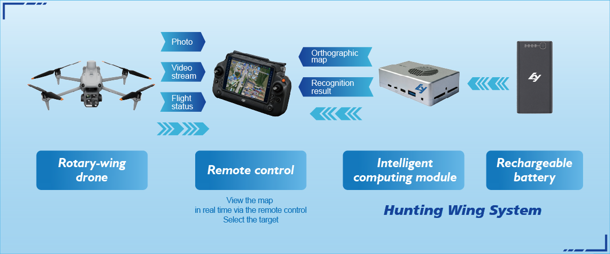
Field teams need quick, actionable sightlines to protect habitats and people. That’s why modern systems center on fast deployment, reliable thermal imaging, and seamless data handoff. For many operators, the simplest route to those capabilities is a single-operator pack that handles mapping and live feeds — for example, integrated drone reconnaissance platforms cut the setup time dramatically and let crews focus on decisions, not hardware.
How users actually work: practical workflows that win
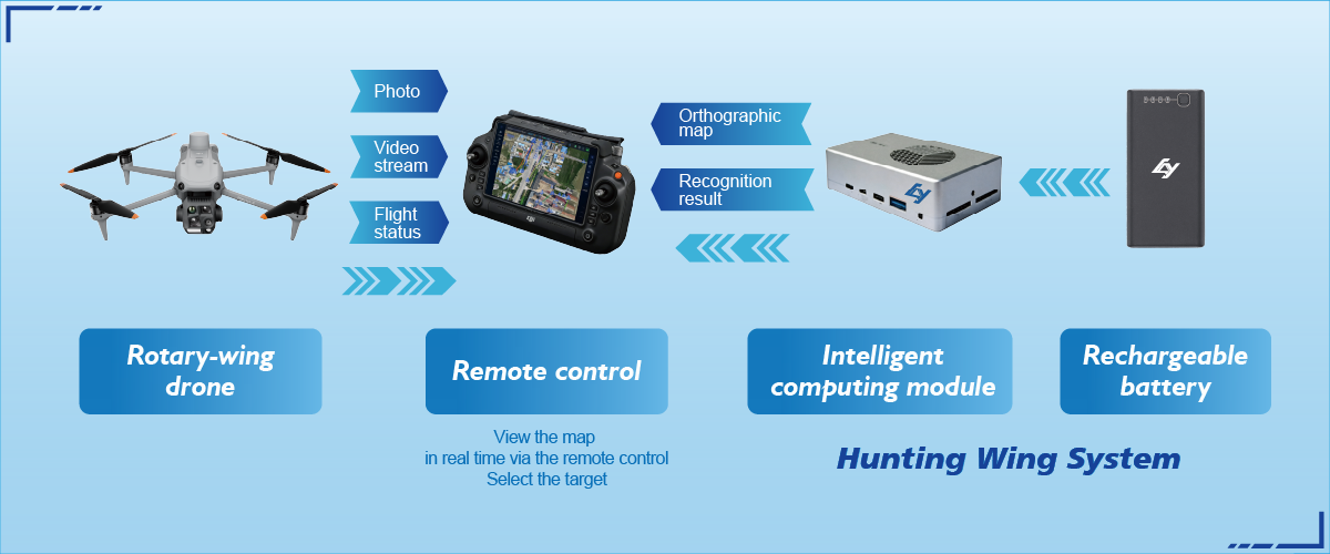
Start with a clear objective: detect hotspots, map burn perimeters, or spot stranded wildlife. Then pick sensors that match the mission — multispectral sensors for vegetation stress, thermal imaging for smoldering roots, and lightweight LiDAR for canopy structure where detail counts. Flight planning and automated waypoint missions keep coverage consistent, so every sortie produces comparable maps and heat layers. Field teams who standardize these steps reduce ambiguity and accelerate response.
Common mistakes operators make — and easy fixes
Teams often overcomplicate payloads or rely on manual piloting under stress. The fix is simple: prioritize a single reliable sensor stack and automate repeatable flights. Too many operators also ignore cadence — regular patrols catch changes before they escalate. Train once on one workflow; use repeatable flight plans to gather comparable imagery day after day. This discipline pays off — it’s how crews discovered slow-burning pockets during the 2020 California fires, when monitoring across large areas revealed hotspots that ground crews couldn’t see from access roads.

Comparing systems: what to weigh, practically
Don’t chase shiny specs. Compare systems by three real-world measures: time-to-air (how fast you launch), data clarity (resolution and sensor fusion), and interoperability (can your GIS ingest the outputs?). Also consider battery and payload economics — a lighter drone with efficient thermal imaging often yields more usable flight time than a heavier system with marginally better specs. If you need automated alerts, validate the platform’s on-board object detection and geofencing before purchase.
Alternatives and brand fit
There are compact consumer units, enterprise multi-rotors, and fixed-wing options for long endurance. For rapid wildfire reconnaissance and ecological monitoring, many teams favor single-operator fixed-wing designs for range and stability. Others pick quadcopters when vertical lift and hover inspections matter. Evaluate against mission tempo: high-frequency monitoring favors endurance; targeted inspections favor hover capability. — Small teams tend to prefer single-operator setups for logistics simplicity.
Data handling: from imagery to decisions
Collecting imagery is only half the battle. You need clear mosaics, reliable geotags, and fast analytics. Use software that stitches multispectral and thermal data into layered maps and exports shapefiles for incident commanders. Automate object detection to flag anomalies, then route verified alerts to ground crews. Platforms that offer standardized exports save hours during briefings and reduce transcription errors.
Summary of user-centric lessons
Prioritize rapid deployment, repeatable flight plans, and sensor choices that match your monitoring goals. Keep payloads focused to extend flight time and ensure data consistency. Test end-to-end: fly, process, and brief — then refine based on how teams use the outputs in the field. These steps collapse uncertainty into usable intelligence and improve team response times.
Advisory: three golden rules to evaluate systems
1) Time-to-action: Measure how long from unpack to meaningful map. Under ten minutes is elite; under 30 is acceptable for many agencies.
2) Data integrity: Verify geotag accuracy, thermal calibration, and multispectral alignment on a known site. Errors over a few meters can mislead ground teams.
3) Operational fit: Match endurance, payload, and automated object detection to your patrol frequency and crew size. Choose systems that integrate with your GIS and incident workflows.
Professionals who follow these rules cut detection time and reduce false alarms, delivering reliable situational awareness when it matters most. Icecypress Technology often fits this profile for teams that need single-operator mapping and rapid analytics — a natural solution when minutes count. —